- You cannot add "Lifesystems Trek First Aid Kit" to the basket because the product is out of stock.
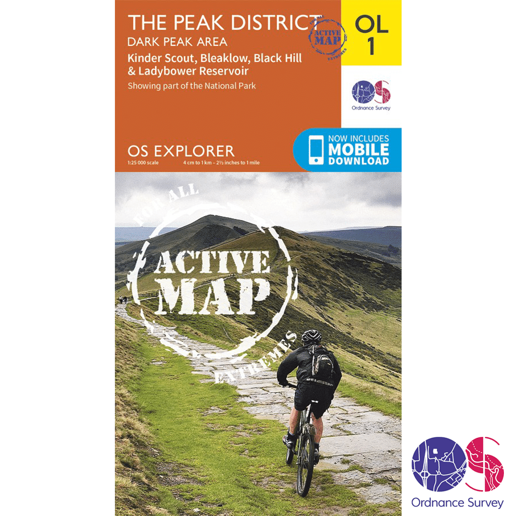
Ordnance Survey Explorer Active – OL 1 – Peaks – Dark Peak
£14.99

Ordnance Survey Explorer Active – OL 1 in the OS Explorer series is ideal for exploring all that the Dark Peak area of the Peak District has to offer. Visitors to this area will enjoy high gritstone hills, steep-sided valleys and moorland plateau. Highlights of the area include: Kinder Scout, The Pennine Way, Edale, Derwent Valley Heritage Way, Ladybower Reservoir, Black Hill, and Glossop.
Out of stock
Description
Ordnance Survey Explorer Active – OL 1 – Peaks – Dark Peak
Explorer – 1:25 000 scale (4 cm to 1 km 2.5 inches to 1 mile)
The essential map for outdoor activities
The OS Explorer Map is the Ordnance Surveys most detailed folding map and is recommended for anyone enjoying outdoor activities including walking, horse riding and off-road cycling. Providing complete GB coverage, the OS Explorer map series details information essential in the great outdoors, including youth hostels, pubs and visitor information. Rights of way, fences, permissive paths and bridleways are clearly shown, ensuring you have the best information to get the most out of your time in the countryside.
You can now discover the landscape in all weathers thanks to OS Explorer Map Active, a tough, versatile version of the OS Explorer map.
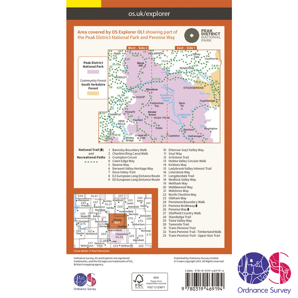
OL 1 – Peaks – Dark Peak features
Walks, trails and paths
- Pennine Way
- Pennine Bridleway
- Gritstone Trail
- Limestone Way
- Middlewood Way
- Cheshire Ring Canal Walk
- Kirklees Way
- Dearne Way
- Holme Valley Circular Walk
- Oldham Way
- Goyt Way
- Longdendale Trail
- Cown Edge Way
- Medlock Valley Way
- Standedge Trail
- Crompton Circuit
- Hills and Hamlets Walk
- Midshires Way
- Dove Valley Trail
- Barnsley Boundary Walk
- Tameside Trail
- Etherow-Goyt Valley way
- Penistone Boundary Walk
- Trans Pennine Trail
- Ladybrook Valley Interest Trail
- Tame Valley Way
- Derwent Valley Heritage Way
- Elsecar to Wortley Trail
- Pennine Way (National Trail)
- E2 (European Long Distance Route)
- Pennine Bridleway (National Trail)
Areas and Locations
- Cheshire
- Peak District National Park
- West Yorkshire
- Greater Manchester
- South Yorkshire
- Derbyshire
Trusted by outdoor enthusiasts from all walks of life, from serious cyclists, to unhurried hikers, the Ordnance Survey Explorer Active – OL 1 map is your essential guide to the Peak District.
With the peaks of Blackhill, Bleaklow and Kinder Scout all covered on the map, walkers and climbers are spoilt for choice. Clearly pinpointed – along with every pub, house, viewpoint, river and right of way – you’ll have no trouble plotting and navigating your route.
Spot populations of pretty birdlife in the Dark Peaks’ patchwork of perfect habitats. Explore peat bogs, limestone crags, heather-clad moorland and brooding gritstone tors. And don’t miss the chance to see the site of the Kinder Scout Mass Tresspass of 1932 – a pivotal point in the fight for better access to the countryside.
Explore oak woods, and walk the Derwent Valley Heritage Way if you prefer a more active option for your days out. At 55 miles long, you might opt to tackle just a short section of the route. Surrounded by stunning scenery, stop off at the must-see Derwent Valley Mills World Heritage Site.
Whatever outdoor pursuits you’re planning, from cycling and sightseeing, to riding and rambling, you’ll find something to cater for every outdoor interest on the Ordnance Survey Explorer Active – OL 1 map of the Peak District.
Ordnance Survey Explorer Active – OL 1 Mapping Area
How to access the digital version of this map
This map comes with a digital version which you can download to your smartphone or tablet.
Go to OS.uk/redeem for more details (terms and conditions apply).
Scratch off the panel on the inside cover of the map to reveal a code, you are then just three easy steps away from downloading your digital map. If the scratch panel has already been scratched off or if you have any problems downloading your map, please call the OS Customer Service Centre on 03456 050505.
Additional information
| Brand | |
|---|---|
| Continent | |
| Country | England |
| County | |
| Location Keywords | Greater Manchester |
| Map Number | |
| Map Title | |
| National Park | |
| Pack | |
| Product Category | |
| Trail Keywords | Barnsley Boundary Walk, Cheshire Ring Canal Walk, Cown Edge Way, Crompton Circuit, Dearne Way, Derwent Valley Heritage Way, Dove Valley Trail, E2 (European Long Distance Route), Elsecar to Wortley Trail, Etherow-Goyt Valley Way, Goyt Way, Gritstone Trail, Hills and Hamlets Walk, Holme Valley Circular Walk, Kirklees Way, Ladybrook Valley Interest Trail, Limestone Way, Longdendale Trail, Medlock Valley Way, Middlewood Way, Midshires Way, Oldham Way, Penistone Boundary Walk, Pennine Bridleway, Pennine Bridleway (National Trail), Pennine Way, Pennine Way (National Trail), Standedge Trail, Tame Valley Way, Tameside Trail, Trans Pennine Trail |
Delivery Information
Shipping is free on all orders for our UK customers!

Orders will be processed and shipped as quickly as possible, however, we are experiencing delays at the moment.
Once your order has been processed it will be shipped by Royal Mail’s 24 or Tracked 24 Service, which delivers Monday to Saturday. Larger or heavier orders are then shipped by DHL.
Orders under £50 will be sent by the Royal Mail 24 Service, which delivers within 48 hours of despatch. Orders over £35 will be sent by the Royal Mail Tracked 24 Service, which delivers within 24 hours of despatch, and any orders over £100 will require a signature.
You will receive a Royal Mail or DHL Tracking Number once your order has been processed.
To avoid disappointment, please contact us if you require the items urgently.
Please don’t hesitate to contact us if you have any questions about delivery.
International Orders
We currently charge £15 for all orders for customers outside of the UK.
Return an Item
Free “No Fuss” Tracked Returns!
Not happy with the product? Item doesn’t fit? Or did we send the wrong item? No problem, we’ll get that sorted for you!
Step 1
Package the unwanted items up, ready to send back.
Step 2
Click the button below to produce a Royal Mail Pre-paid Returns sticker, making sure to include your order number.
You will also be emailed a QR code that you can take to the Post Office, so they can produce your sticker – should you not have a printer.
Step 3
Take the package to your nearest Post Office.
We will then be notified by Royal Mail that you are returning something.
Step 4
We will check the package in when it arrives with us and arrange your refund as quickly as possible. This is usually within 1 working day of the item arriving back. You will then get an email confirming that the refund has happened and you should receive your refund either back to your card or PayPal account within 24-48 hours. If you have any questions or concerns, please get in touch.
Related products
-
 Recommended Retail Price: £7.99


Reviews
There are no reviews yet.